sábado, 12 de marzo de 2016

Ibón d'Estanés desde Parking Sansanet / Estanés lake from Sansanet Parking - Aspe Valley


Track Description / Características de la Ruta:

Distance / Distancia: 10.30km 
Elevation Gain / Ascenso: 872m
Max / Min Altitude:  1867m / 1206m
Difficulty / Dificultad: Easy / Fácil
Alpine Grade: S.D. 
Activity: Snowshoeing / Raquetas de nieve.
Material: Snowshoes / Raquetas de nieve.
Recommended Cartography / Cartografía Recomendada: 
-Editorial Alpina, Valle de Canfranc. 
-IGN TOP 25 Ossau, Vallée d'Aspe.


Past May we explored the surroundings of Ibón d'Estanés (see this post), a glacier lake in Pyrenees region of "La Jacetanea". That time we got to the Lake walking through the valley of Aguas Tuertas. Past February we came back to the area to visit the same spot, but this time with a quite different picture, with a decent amount of powder snow. // El pasado mayo exploramos los alrededores del Ibón de Estanés (ver este post), un lago glaciar en la región de la Jacetania en los Pirineos. Aquella vez subimos al Ibón desde el Valle de Aguas Tuertas. En febrero, aprovechando la buena innivación del valle, aprovechamos para repetir la actividad y conocer otros parajes cercanos.

The snowshoeing walk starts at the parking of Sansanet, in France, at the Valley of Aspe. Crossing the French-Spanish border through the col de Somport (or through Somport Tunnel), we descend the mountain road and after a few sharp curves, we will see the parking signal of Sansanet. The parking space is very limited, and in winter time, there are only a few places available given that the parking is not usually clean of snow. If we get there early we will avoid parking on the road side. // El paseo de raquetas de nieve comienza en el parking de Sansanet, en el Valle de Aspe, lado Francés. Cruzando la frontera a través del puerto de Somport, o bien por el túnel de Somport, descendemos la carretera de montaña, y después de unas cuantas curvas cerradas llegamos a la señal del Parking de Sansanet. El espacio para aparcar es muy limitado en invierno, ya que el parking no lo limpian de nieve, así que es buena idea madrugar un poco si queremos evitar aparcar en el borde de la carretera.

The first few hundred meters the walk flows through a closed forest of trees. // Los primeros metros de la caminata caminamos por un denso bosque.


The path is evident and correctly marked with sign-posts and the GR-11 red and white marks in the Spanish side. After one kilometer, we can spot the Cabanne d'Escouret, a shepherd hut used for cheese making in summer time. // El camino es evidente y correctamente marcado por las pinturas rojas y blancas del GR-11 en el lado Español. Tras 1km de caminata desde el parking vemos la Cabaña de Escouret, una cabaña de pastores que en verano es usado como quesería.


Once we ascend above the 1600m level, the forest disappears at the level of Mugarri number 292, the rock blocks which demarcate the French-Spanish border. // Una vez ascendemos por encima de los 1600m, el bosque desaparece a la altura del Mugarri 292, los bloques de piedra que demarcan la frontera Franco-Española.


The views to the Cirque de l'Aspe are quite impressive. // Las vistas hacia el Circo del Aspe son impresionantes.

The GR-11 flows through a wide valley with a lot of snow accumulation due to the effect of North winds of the past days. // El GR-11 progresa por un ancho valle con bastante acumulación de nieve debido al efecto del viento del norte de los días pasados.

Views are amazing, and the smooth hillsides make this terrain free of avalanches at the valley level. // Las vistas son impresionantes, y las suaves laderas hacen de esta zona un terreno casi libre de avalanchas a nivel del valle.


Gaining elevation, with the hillsides of La Mujer Muerta hiding the Estanés Lake. // Ganando altura, las lomas de La Mujer Muerta nos ocultan el Ibón de Estanés.


We might find a couple of avalanche exposed spots where, in case of big snow accumulation, it might be wise to cross individually. // En el trayecto podemos encontrar un par de puntos expuestos a las avalanchas en caso de grandes acumulaciones de nieve, puede ser inteligente cruzarlos individualmente.


The giants surrounding Estanés Lake (Pico Labata, Pico Liovilla, Pico de la Portaza) are beautiful covered by the snow. // Los gigantes que rodean el Ibón de Estanés (Pico Labato, Liovilla y de la Portaza) están preciosos con su manto blanco.


Views to the French side of Aspe Valley. // Vistas hacia el lado Francés del Valle de Aspe.


Again, flat terrain, smooth hillsides, make of this terrain quite a safe area for avalanches. // De nuevo, terreno llano, laderas suaves, hacen de este terreno bastante seguro para las avalanchas.


After 4km, we can spot the frozen glaciar Lake, Ibón d'Estanés. // Después de 4km podemos ver el lago glaciar de Ibón de Estanés.

The wind was very strong the previous days, blowing away the snow off the north face of Pico de Acué. // El viento de Norte de los pasados días limpió de nieve las laderas del Pico de Acué.


Pico de la Portaza and Pico Liovilla, surrounding Estanés Lake. // Pico de La Portaza y Liovilla, rodeando el Lago de Estanés.

To avoid coming back through the same path, we ascended La Mujer Muerta summits. Again, mild hillsides with wide ridges, a terrain safe from avalanches most of the days of winter. // Para evitar volver por el mismo camino, ascendemos por las cimas de La Mujer Muerta. De nuevo, suaves laderas con anchas crestas, un terreno no muy expuesto a las avalanchas la mayoría de los días de invierno.


At the background we can see Astún ski resort, and La Raca peak. // Al fondo, podemos ver la estación de Ski de Astún y el pico de La Raca.

Using the mild hill sides, we descend back to the original track, which will lead us back to the parking of Sansanet. // Usando las suaves laderas, descendemos de nuevo al camino original, que nos llevará de vuelta al Parking de Sansanet.

Summary/Resumen:
- Easy snowshoeing activity in winter time. // Fácil actividad de raquetas de nieve.
- The access to Estanés Lake in winter is much easier from the Sansanet parking place than from Aguas Tuertas, as we did in May. However, in spring/summer time, I prefer the Aguas Tuertas activity, since it is longer and more impressive. // El acceso al Ibón de Estanés en invierno es mucho más fácil desde el parking de Sansanet que desde el Achar de Aguas Tuertas, como lo hicimos en Mayo. Sin embargo, en primavera y verano, prefiero personalmente la ruta desde Aguas Tuertas, mucho más impresionante.
- In winter time, with the parking space very limited, it is important to arrive early to Sansanet to avoid parking on the road side. // En invierno, importante no llegar muy tarde a Sansanet si nos queremos agenciar un buen sitio para aparcar.

miércoles, 10 de febrero de 2016

San Lorenzo Winter North Face / Invernal Cara Norte. Tubo de las S. (40m / 35º / PD)


Track Description / Características de la Ruta:

Distance / Distancia: 5.70km 
Elevation Gain / Ascenso: 793m
Max / Min Altitude:  2269m / 1544m
Difficulty / Dificultad: Difficult / Difícil
Alpine Grade: P.D. (Snow couloir 40m, 40 degrees)
Activity: Winter Mountaineering / Alpinismo Invernal .
Material: Ice axes and crampons compulsory / Piolets y crampones obligatorios.
Recommended Cartography / Cartografía Recomendada: 


La sierra de la Demanda o de Arandio, como antiguamente era llamada, reune varias decenas de picos de 2000m en las provincias de La Rioja y Burgos. Adicionalmente, hospeda la cima más alta de ambas comunidades, el Monte San Lorenzo en La Rioja y el Monte San Millán en Burgos. En esta actividad ascenderemos el Monte San Lorenzo en modalidad invernal. Siendo la montaña más alta de la provincia de La Rioja, existen numerosas vías de ascensión, siendo las más interesantes desde el punto de vista del alpinismo las que ascienden por su cara norte. // La Demanda Mountain Range, or Arandio Mountain Range as it was named in the past, gathers several tens of 2000s meters peaks in the provinces of La Rioja and Burgos. Additionally, it hosts the highest peaks in both provinces, San Millán peak at the province of Burgos and San Lorenzo peak at the province of La Rioja. In this activity we climbed the Mount San Lorenzo in winter conditions. Being the highest mountain in La Rioja, there exist many different routes for the summit ascent, being the most interesting from a mountaineering point of view the ones going up through the North face.


En la imagen superior podemos ver los tubos de las S y los tubos de la Hoya, fáciles corredores invernales que nos permiten alcanzar la cumbre del San Lorenzo por un terreno  alpino. En esta actividad ascendimos por el tubo derecho de los Tubos de las S, el más fácil y corto, para luego seguir por la ancha arista que define la Hoya. Poco a poco iremos posteando nuevas actividades que recorren los otros corredores. // In the above picture we can see the "Tubos de las S" and "Tubos de La Hoya", which are the different snow couloirs which give access to the summit of San Lorenzo through an alpine terrain. Other less difficult routes are possible as well. "Tubos de las S", the one described in this activity, are probably the easier couloirs in the North Face. We will post in the future another blog entry with the description of the other corridors.

Si queremos acometer la ascensión en modalidad invernal con menos dificultad pero más seguridad, podemos seguir este otro track realizado hace unos cuantos años. En aquel momento el día era mucho más soleado y me permitió hacer muchas de las fotos que expongo en este post. // If we want to ascend Mount San Lorenzo through a less difficult route, we can follow this older track I did a few years ago. At that time, the day was clearer and snow conditions better, which allowed me to take better pictures which I will be using in this blog entry.


La temporada 2015/2016 está siendo muy suave, con pocas precipitaciones en forma de nieve. Aunque la situación no era ideal para el ski, en la Hoya Norte había nieve suficiente para hacer actividades invernales. La nieve estaba bastante húmeda hasta la cota 1900, apareciendo nieve dura que nos permitió avanzar con seguridad hasta la cumbre por la pala final con el uso de dos piolets. Como siempre, no hay que dejarse engañar por la montaña, por muy fácil que pueda parecer una actividad, hay que extremar las precauciones, especialmente en presencia de nieve. Aunque la acumulación de nieve no era grande, hacía dos semanas que un esquiador de travesía había perdido la vida en un alud a muy pocos metros de la cima del San Lorenzo, tal y como describe la noticia en el periódico de El Mundo. // The 2015/2016 winter season is being a mild one, with just little snowfall. Although the snow conditions were not good for the practice of ski, the North Face of San Lorenzo had enough snow to ascend any of the winter routes. Snow was very humid until 1900m level, but from there to the top the conditions were very good, with a hard snow on which crampons and iceaxes gave us a sense of safety. As usual, even in the smallest mountains, snow activities can be very misleading and we have to take our own safety measures. Not only we should be correctly equipped, but we have to look at the snow conditions. Even if the snowfall has been very week this winter season, two weeks before doing the activity a skier was found dead buried in a snow avalanche in the south slopes of San Lorenzo, as the newspaper El Mundo reported in this piece of news .


La actividad comienza en el parking de la estación de Esquí de Valdezcaray. Como no hay mucha nieve, no habia problemas de espacio, pero en general, se recomienda llegar pronto. Haciendo uso de las pistas, ascendemos por la Pista Verde de la Cascada que sale del mismo Parking. Una vez en el telesilla de Rehoyo, ascendemos paralelo a las pilonas hasta la zona del telesilla de Campos Blancos. // The activity starts at the parking lot of the ski resort, Valdezcaray. Since there is not a lot of snow, there was plenty of parking space that day, but it is recommended to arrive early. Using the green ski run "La Cascada", we start walking up to Rehoyo chairlift. Once at the base of Rehoyo chairlift, we ascend parallel to the pillars of the chairlift until we get to the chairlift of Campos Blancos, at around 1800m.


En ese punto estamos ya casi en la base de la Hoya. Si queremos acceder directamente a la Hoya Norte, tendríamos que remontar un poco más por la pista de Colocobia. Puesto que nuestro destino son los Tubos de las S, en concreto el derecho, comenzamos a ascender directamente desde la llegada del telesilla de Rehoyo. // At this point we are at the beginning of the North Face. If we want to ascend the couloirs of Hoya Norte, we should go up further on the ski run of Colocobia. Since today target is the couloir of Los Tubos de las S, we ascend directly at the end station of the chairlift of  Rehoyo.


La nieve esta bastante húmeda, pero la inclinación hasta llegar al corredor es poca. Afortunadamente hay base suficiente para poder meter el piolet hasta el fondo, ya que con la nieve tan blanda los crampones no agarran bien en la pendiente de 35 grados. // The slope to the base of the couloir is moderate. Once at the corridor, the snow is quite humid, fortunately there is enough snow so that we can traction using the iceaxes, since the crampons do not grip quite well on the humid snow.


Poco a poco vamos ganando altura, el corredor se abre y comienza una pala de nieve que nos conducirá hasta la cima del San Lorenzo. Aunque no tiene mucha inclinación, un resbalón aquí tiene consecuencias fatales. // Step by step we gain elevation, the couloir opens and a wide slope of snow will lead us to the summit of San Lorenzo. Although it is not too steep (around 25 degrees), a trip in this terrain and we will end a few hundreds meter down.


Aprovechando la ancha arista que forma La Hoya Norte, vamos ascendiendo poco a poco, contemplando los diferentes Tubos de la cara Norte del San Lorenzo. Poco a poco iremos colgando reportajes sobre los mismos. // We advance using the wide ridge which defines Hoya Norte (the old glacier circus), ascending step by step, with good views of the couloirs of Hoya Norte. We will post new entries in the blog for these activities.


A medida que ascendemos la nieve tiene mejor calidad, más acumulación y más dura, lo que nos permite avanzar cómodamente por la pala de nieve final. Al final vislumbramos ya la imagen de la Virgen de Valvanera en el altar del San Lorenzo. Tras enviar unos mensajes por wassup para confirmar que estamos bien (existe cobertura en la cima), descendemos hacia la llegada del Telesilla Campos Blancos. La bajada tiene una nieve estupenda pero peligrosa. El viento de los días pasados debió acumular bastante nieve en esta ladera, que fue la que provocó el alud al paso del esquiador que murió. // As we ascend, the snow has better quality, deeper accumulation and gets harder, making safer the ascend on the last meters of the slope. When we catch a glimpse of the virgin statue at the summit, we know we have reached the highest point. After a few text messages (there is mobile reception on the summit), we descend towards the chairlift of Campos Blancos. The snow accumulation seems to be bigger on this side.


El día estaba bastante cubierto y las vistas desde la cima no daban mucho de sí. Con suerte se veía el Cabeza Parda, con bastantes calvas sin cubrir por la nieve. // The day was overcast, and we hardly had views from the summit. At the end we could distinguish Cabeza Parda, another 2000s close to San Lorenzo.


Desde la llegada del Telesilla Campos Blancos descendemos por la larga pista azul del mismo nombre. Tras descender unos metros atravesamos las vallas de madera y nos metemos por un pequeño hueco que da paso a la pista negra de "Las S". Desde ahí aprovecharemos la pista negra para descender andando hasta coger la linea de las pilonas del telesilla, apareciendo casi en la base del corredor que ascendimos. En este tramo aprovechamos para descender con la técnica del piolet-escoba, dado que la pendiente no es demasiado pronunciada. // On the way down, we descend to Campos Blancos chairlift, and then through the blue ski run with the same name. After a few meters, we cross the wooden fence and step in the black ski run names as "Las S". We use the steep ski run to descend until the base of the couloir we did on the way up.


Una vez en el telesilla, aprovechamos la pista azul de "Los Tubos" para descender rápidamente hasta la llegada del Telesilla de la Cascada, donde de nuevo descenderemos al parking por la pista verde de la Cascada. // Once we are back at the chairlift, we use the "Los Tubos" blue ski run to return to "La Cascada" chairlift, and then a few meters down, to the parking place.


Este es el pobre aspecto de la Cara Norte del San Lorenzo el dia de la actividad. Como se puede apreciar, la Hoya Norte permitía actividades invernales, pero para la práctica del esquí estaba bastante escaso. // This is the panorama of the North Face of San Lorenzo on the day of the activity. As we can appreciate, snow cover for the time of the year is very poor, although the practice of the winter routes was doable.


Las siguientes fotos fueron tomadas unos años atrás en el mes de Marzo, con bastante mejor innivación, desde la pista de Campos Blancos. Muestran claramente el recorrido realizado en esta actividad. // The following pictures were taken a few years back at the end of March, with a much better snow cover, from "Campos Blancos" ski run. We can see in red the activity we did today.


Desde la carretera descendiendo al pueblo de Ezcaray. // Views from the road down to Ezcaray, at the end of March a few years back.


Resumen // Summary:
- Fácil actividad invernal para la que es obligatorio el uso de crampones y piolets. De las posibles ascensiones alpinas por la cara norte del San Lorenzo, este tubo es uno de los más fáciles. // Easy winter activity, compulsory use of iceaxe and crampons. This couloir is the easiest route of the North Face of San Lorenzo.
- Aunque el San Lorenzo sea una montaña modesta, no por ello puede resultar menos peligrosa. Dos semanas antes de la actividad hubo un muerto por alud de nieve en la cara sur, en el valle del Calamantío. Así que es necesario extremar las precauciones y leer en todo momento las condiciones de la nieve. // Although San Lorenzo is not a high peak, it is equally dangerous on winter time. Two weeks before the activity a skier was dead due to a snow avalanche, so be aware of the snow conditions before embarking in any winter activity.
- Existen otras posibles ascensiones en invierno. Las más fáciles serían subir por la pista de Campos Blancos con raquetas (ojo en los últimos metros a la cima, suele estar helado por la acción del viento), o bien desde el Telesilla de Colocobia. En este caso, el camino suele ir junto a la arista del Hoyo Norte, así que tenemos que ir con cuidado para no resbalar y caer en la Hoya. El resto de ascensiones por la cara norte son más alpinas y requieren el uso de crampones y piolets. // There are other possible ascent routes for winter. The easiest one is through "Campos Blancos" or "Colocobia" ski runs, snowshoeing. Be aware since the summit is usually covered by ice on its last meters due to strong wings.

sábado, 2 de enero de 2016

New Zealand - Fiorland - Key Summit

Track Description / Características de la Ruta:


Distance / Distancia: 4.14km 
Elevation Gain / Ascenso: 456m
Max / Min Altitude:  972m / 526m
Difficulty / Dificultad: Easy / Fácil
Alpine Grade: S.D. (Sin dificultad)
Activity: Hiking / Senderismo 
Recommended Cartography / Cartografía Recomendada: 


On our way to Fiorland, in the South Island, the road from Te-Anau to Milford is plenty of beautiful hikes which can be finished in just a few hours. Close to the parking place of Marian Lake, which we visited on the way to Milford, we find Key Summit, a modest mountain with beautiful views of the surrounding valleys and peaks of Fiorland. // De camino a Fiorland, en la Isla Sur, la carretera de Te-Anau a Milford está llena de recorridos maravillosos que pueden ser hechos en tan sólo unas horas. Cerca del parking de Marian Lake, que visitamos en nuestro viaje de ida a Milford, encontramos Key Summit, una modesta montaña con preciosas vistas de los valles y picos que le rodean.


By the road side, we find a big parking place with public toilets. The parking place is usually packed, since this is the starting/end point of the Routeburn track, one of the most famous multi-day treks in New Zealand. The track starts in Glenorchy, where we ascended Mount Alfred a few days before. From the parking place, we will follow for about 2.5km the Routeburn track. Then we will find a fork in the track. The path in our left is the Routeburn track, to ascend the Key Summit we will keep on our right. // A un lado de la carretera encontramos un gran parking con servicios públicos. El parking normalmente está muy frecuentado dado que es el inicio/fin del Routerburn track, uno de las actividades de senderismo de varios días más famosas de Nueva Zelanda. El track empieza en Glenorchy, donde ascendimos el Mount Alfred unos días atrás. Desde el parking, seguimos el camino  del Routeburn track unos 2.5km. Una vez llegados a la intersección, el camino de la izquierda es el del Routeburn track, nosotros nos quedamos en el de la derecha que asciende hacia el Key Summit.


As we ascend the slopes of Key Summit, the native forest disappears, and we get wonderful views of the valley where the road to Milford runs. // A medida que ascendemos las laderas de Key summit, el bosque nativo desaparece, y tenemos vistas maravillosas del valle por el que trascurre la carretera que lleva a Milford.


In front of us, we see the hanging glacier valley of Lake Marian, which we visited on the way to Milford the day before. // En frente de nosotros, el valle glaciar colgante donde se sitúa Lake Marian, que visitamos en nuestro camino de ida a Milford.


Summary / Resumen:
- Easy and short hiking activity with wonderful views on the surrounding area. Worth to visit on the one to or back from Milford sound. // Fácil y corta actividad con maravillosas vistas. Merece la pena visitarla a la ida o vuelta de Milford Sound.

viernes, 1 de enero de 2016

New Zealand - Okere Falls

Track Description / Características de la Ruta:

Distance / Distancia: 2.45 km 
Elevation Gain / Ascenso: 70m
Max / Min Altitude:  390m / 342m
Difficulty / Dificultad: Easy / Fácil
Alpine Grade: S.D. (Sin dificultad)
Activity: Hiking / Senderismo 
Recommended Cartography / Cartografía Recomendada: 


In the Bay of Plenty, close to Lake Rotorua, we find Okere Falls. On the Kaituna river, on its way to Pacific Ocean, one of the drains of the lake has formed a nice spot for extreme rafting and kayaking. For those who do not practice any of these sports, there are a conditioned path going along the river to enjoy the beauty of the place. If you are interested in whitewater rafting on the area, visit the DOC website for Okere Falls in order to look for commercial operators. // En la Bay of Plenty, cerca del Lago Rotorua, encontramos las cascadas de Okere. En el río Kaituna, en su camino hacia el océano Pacífico, este sumidero natural del lago ha formado un entorno maravilloso para el kajaking y el rafting. Para aquellos que no practican estos deportes, existe también un camino acondicionado a lo largo de la primera parte del río que nos permite descubrir la belleza del lugar. Si estás interesado en actividades de rafting en la zona, visita la web del DOC para las Okere Falls con el fin de buscar operadores comerciales que trabajan en la zona.


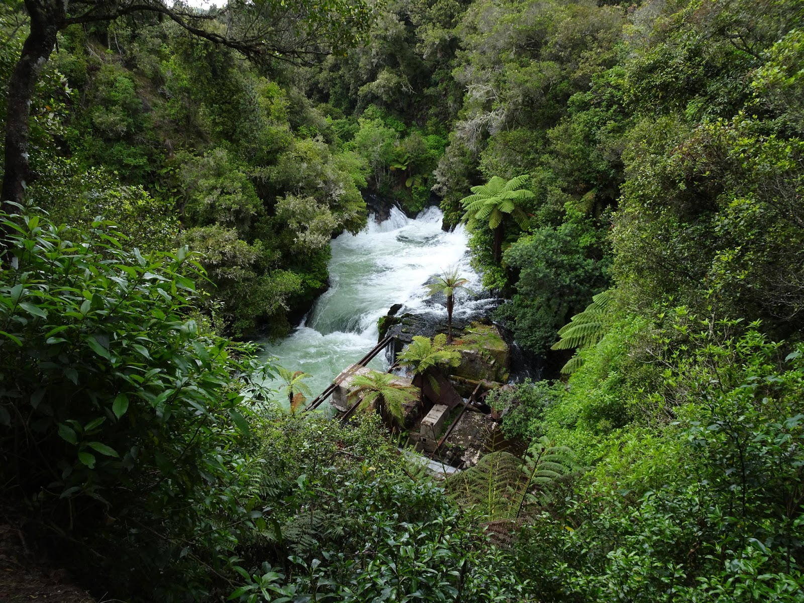
The path along the river is well marked, and we can get nice views from the small waterfalls. // El camino a lo largo del río está bien marcado, y tenemos buenas vistas de las diferentes cascadas.


Along the path we spotted several entry/exit points for kajaking and rafting. // A lo largo del camino vemos varios puntos de entrada y salida para kajaking y rafting.


At the end of the path, close to the second parking place, there are a nice look-out with a bridge crossing the river. Be careful if you go down to the river level, the rock is very slippery and the water stream very strong. // Al final del camino, cerca al segundo parking, existe un mirador y un puente que cruza el río. Tened cuidado si bajáis al nivel del río, ya que la roca es bastante resbaladiza y la corriente de agua muy fuerte.


On the way back, we visited the ruins of an old water power station, as well as the cove in the main waterfall. This place was used by native population as a shelter in time of wars. // En el camino de vuelta, visitamos las ruinas de una antigua estación hidroeléctrica y una cueva que existe en la cascada. Al parecer, este lugar fue usada por la población nativa como un refugio en tiempos de guerra, dada su inaccesibilidad.


Summary / Resúmen:
- Easy 1 hour hike to visit the first section of the Kaituna river. Walking along a conditioned path, you are not expected to leave the path, falling down to the river might have undesired consequences. // Ruta fácil de 1 hora que nos permite conocer la primera parte del río Kaituna. Caminad siempre a lo largo del sendero acondicionado, con la fuerte corriente de agua, caer en el río puede tener consecuencias no deseadas.

New Zealand - Lake Okataina


Track Description / Características de la Ruta:

Distance / Distancia: 12.60 km 
Elevation Gain / Ascenso: 363m
Max / Min Altitude:  509m / 395m
Difficulty / Dificultad: Easy / Fácil
Alpine Grade: S.D. (Sin dificultad)
Activity: Hiking / Senderismo 
Recommended Cartography / Cartografía Recomendada: 


Starting our New Zealand adventure on the North Island, one of the mandatory stops is the area of Bay of Plenty and Rotorua. The Okataina Lake has a lot of possibilities, from tramping and one-day hiking to mountain biking, kajaking and fishing. // Comenzando nuestra aventura Neo Zelandesa en la isla Norte, una de las paradas obligatorias es la Bahía de Plenty y la zona de Rotorua. El Lago Okataina tiene muchas posibilidades, desde senderismo de varios días y excursiones de unas horas, hasta bici de montaña, canoa y pesca.


By the parking place, we have a hotel, a bar/restaurant as well as public toilets. I do not remember if free camping was allowed at this place, but with no doubt, staying overnight on the lake's shore must be a nice experience. By the public toilets, we see a map with the hiking/tramping activities we can do on the area. // Junto al parking tenemos un hotel, bar/restaurante así como baños públicos. No recuerdo si la acampada libre está permitida en este lugar, pero sin duda, pasar una noche a orillas del lago debe ser una experiencia maravillosa.


We hiked the path going along the shore of the lake. The walk go till the Lake Tarawera camping area, but we shortened the activity to a 4 hours return hike. Enough to catch the beauty of the area. // Caminamos por el sendero que discurre por la orilla del Lago. El sendero va hasta la zona de camping del Lago Tarawera, pero acortamos la actividad a una caminata de 4 horas ida y vuelta. Lo suficiente para captar la belleza del lugar.


The forest, as many others areas in New Zealand, is full of possum traps, in order to combat this invasive specie which is killing the local birds such as Kiwis and Keas. // El bosque, como muchas otras areas de Nueva Zelanda, está llena de trampas para possum, con el fin de combatir la especie invasora que está matando a mucha fauna local, especialmente Kiwis y Keas.


On the way back to the parking, with the sunlight of the noon, the lake water reminds me to exotics Caribbean beaches. // De vuelta al parking, con la luz del mediodía, las aguas del lago me recuerdan a exóticas playas del Caribe.


Remarks:
- Easy activity, well marked path, we can find a couple of beaches in the track in case we want to refresh our bodies. // Actividad facil, camino bien marcado, podemos encontrar un par de playas en el camino en el caso que nos queramos refrescar.
- There is no water sources on the whole path, so, bring water with you. // No hay agua durante todo el recorrido, así que es importante llevarsela.
- Visit the DOC website for more information on other activities and commercial operators. // Recomiendo visitar la página web del DOC para tener más información sobre la cantidad de actividades y operadores comerciales de la zona.