sábado, 15 de agosto de 2015

Peña del Cuco desde La Barranca


Track Description / Características de la Ruta:

Distance / Distancia:  11.5km
Elevation Gain / Ascenso: 561m
Max / Min Altitude:  1866m / 1302m
Difficulty / Dificultad: Easy / Fácil 
Alpine Grade: S.D. (Sin dificultad)
Activity: Hiking / Senderismo
Recommended Cartography / Cartografía Recomendada: Sierra de Guadarrama - Editorial Alpina.


Barranca Valley is a small and narrow valley close to the village of Navacerrada, 50km from Madrid. Delimited by the South Face of La Bola del Mundo (Alto de las Guaramillas), the ridge of Cabrillas (Cresta de las Cabrillas) and La Maliciosa.  Paths at La Barranca, although not long, are a good choice for the hot afternoons of summer, since, once the sun starts falling from the zenith, the valley is covered by shade, making it possible to hike even in the warmest days of summer. Furthermore terrain is very easy, and most of the paths are signaled very well, so, we can extend the activity until the last hours of the day with no fear of being in the darkness. // El valle de La Barranca es un pequeño y encajonado valle cercano a la localidad de Navacerrada. Delimitado por la Cara Sur de La Bola del Mundo (Alto de Las Guaramillas), La Cresta de las Cabrillas y La Maliciosa. Los senderos por La Barranca, aunque no son muy largos, son una buena opción en las cálidas tardes de verano, ya que una vez el sol comienza a bajar hacia el horizonte, el Valle se cubre de sombra, haciendo posible pasear incluso en los días más fuertes del verano. Además el terreno es fácil, y la mayoría de los senderos bien marcados, con lo que podemos extender la actividad hasta casi sin quedarnos sin luz sin mucho miedo a perdernos.

Cuco crag is the crug located halfway between Risco de Los Emburriaaderos, on Las Cabrillas ridge, and Peña Cabrita creek, right by the "Pipeline path" or "Camino de La tubería". The rock has three traditional climbing routes (from III to V+ level, see below), and a small ridge, making from it an ideal environment to learn and practice the progression on this kind of terrain. // Peña del Cuco es la Peña que se encuentra a medio camino entre El Risco de Los Emburriaderos, ya en la Cresta de Las Cabrillas, y el Arroyo de Peña Cabrita, junto al camino de la Tubería. La Peña tiene tres vías de escalada clásica (desde III a V+, ver croquis más adelante), y una pequeña cresta, haciendola un entorno ideal para practicar la progresión sobre crestas y aristas.

For a climbing sketch of Cuco's crag, visit the link below:

Blog: http://antonio-segundatemporada.blogspot.com.es/2014/08/pena-del-cuco-navacerrada.html
There is an especial article in 28 number of the Altitude quarterly magazine, you can find the pdf on this link (pag 36).// También existe un artículo en el número 28 de la Revista Altitud (Federación Madrileña de Montaña), podéis conseguirlo en el siguiente link (pág 36).

As most of the activities within Barranca Valley, the hike starts in the parking lot close to the dam Embalse del Pueblo de Navacerrada (do not confuse with Embalse de Navacerrada) and dam of Ejército del Aire. The easiest way to arrive at the parking lot is driving the M-601, at the crossroad of Cercedilla/Cerceda/Puerto Navacerrada, continue to Cerceda. After a few minutes we will find a narrow road on our left, signaled as "La Barranca". Once on the narrow road, we will drive until the end of the road, once we have passed the fire station and the abandoned hospital. // Como la mayoría de las rutas en el Valle de la Barranca, la actividad comienza en los parkings junto al embalse del Pueblo de Navacerrada (no confundir con el Embalse de Navacerrada) y el Embalse del Ejército del Aire. Existen varias alternativas para llegar a este parking, para mi la más fácil es continuar por la M-601 hasta el cruce de Cercedilla/Cerceda/Puerto Navacerrada. En dicho cruce nos vamos dirección Cerceda hasta que veamos una estrecha carretera con un cartel indicando La Barranca. Una vez en la Carretera seguimos todo recto (pasando por el parque de Bomberos y el Antiguo Hospital, ahora abandonado) hasta llegar a los dos parkings al final de la carretera.


A PR path (white and yellow painted marks) starts from the parking. After a few minutes we will pass by Fuente del Mingo (water source). A few minutes later, there is a fork on the path, the path to the East leads to Collado del Piornal, a popular path leading to Maliciosa summit. We will take the one on our left to continue heading West. //  Desde el parking comienza un sendero PR (blanco y amarillo). Al poco de comenzar tenemos una fuenta a pie de Sendero, Fuente del Mingo. Un poco más arriba existe una bifurcación, el camino hacia el Este asciende hacia la Maliciosa por el Collado del Piornal, nosotros sin embargo seguiremos en la pista forestal hacia el Oeste.


Once we cross Peña de Cabra creek, a small path on our right leaves the main path and ascends in the pinetree forest. We can equally keep on the main path, which we will use for the way back, but the distance is longer. //  Tras pasar el Arroyo de Peña de Cabra, un pequeño camino a nuestra derecha abandona la pista forestal y asciende entre el bosque de pinos. Igualmente podríamos haber seguido por la pista forestal, pero el camino se hace más largo en este caso.


As we ascends the pinetree forest opens, and we have privileged views of Cresta (ridge) de las Buitreras and Maliciosa. The shade is climbing up quickly through the hillsides of La Maliciosa. // Desde el camino, aprovechando los claros entre los pinos, podemos observar la Cresta de las Buitreras y los Riscos de la Maliciosa. Observamos en la foto como la sombra va asciendendo rápidamente por las Laderas de la Maliciosa.


The path ascends now on the hillsides of Cuerda de Las Cabrillas, until the pinetree forest ends. From this  point we have now direct view of Peña del Cuco, Alto de las Guaramillas (Bola del Mundo) and Riscos de la Maliciosa. // El camino asciende por la ladera de la Cuerda de Las Cabrillas hasta que termina el bosque de pinos. Desde este punto ya tenemos visión directa con Peña del Cuco. También podemos ver El Alto de las Guaramillas, los Riscos de La Maliciosa.


Peña del Cuco is this big crug in the middle of the valley, an area known as Garganta del Infierno (Hell's gorge). // Peña del Cuco es este bloque de piedras que se encuentra en medio del Valle, y que baja casi hasta el Arroyo de Peña de Cabra, en la Garganta del Infierno.


This is the end of Peña del Cuco, where the ridge ends, close to the path, the climbing routes are on the opposite side of the crug. // Parte final de Peña del Cuco, donde termina la Cresta. Las vías de escalada empiezan justo en el extremo opuesto.


From this point we have a privileged view of Barranca Valley, which we just walked up. // Desde Peña del Cuco tenemos una vista perfecta de todo el Valle de La Barranca hasta Cabeza Mediana.
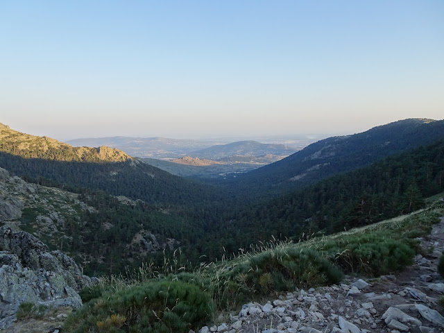


And the shade climbs upper and upper as the sun sets. // La sombra cada vez trepa más alto por la Cuerda de Las Buitreras.


For the way back, we take the "Pipeline path" or "Camino de la Tubería". It is easy to identify since we can see and old iron pipeline on the side of the path, I guess it was used to provide Navacerrada village with water in the old times. //Para descender tomamos el Camino de la Tubería. Se llama así porque a lo largo del mismo puede observarse una antigua tubería de hierro que antiguamente supongo abastecería al pueblo de Navacerrada.


The path ascends to Cuerda de Las Cabrillas, to the summit of Risco del Emburriadero, and then gets back to the principal path we used on our way up. From the summit of Cuerda de las Cabrillas we have views to the valley of Puerto de Navacerrada. // El camino asciende temporalmente hacia la Cuerda de Las Cuadrillas hasta el Collado del Emburriadero para luego volver a la Pista Forestal que abandonamos antes. Desde el Collado tenemos vistas hacia el Valle por el que asciende la Carretera del Puerto de Navacerrada...


and to  Siete Picos summits... // así como de la zona de Siete Picos...


Orange color in La Maliciosa (this is the golden hour, as the professional photographers says), the shades has already achieved  Collado del Piornal. // Colores Anaranjados (Golden Hour como dicen los entendidos de Fotografía) en la Maliciosa. La Sombra ya llega hasta el Collado del Piornal.


Collado de Los Emburriaderos, en la Cresta de Las Cabrillas.


Once we are back on the principal path, at Mirador de Las Canchas or La Barranca (viewpoint), we descend toward Valle de La Barranca. Be careful not to descend to the other side, since you will end up at Puerto de Navacerrada road. // Una vez cogemos la pista Forestal, a la altura del Mirador de las Canchas o de La Barranca hacemos la curva de herradura y descendemos de nuevo hacia el Valle de La Barranca. Cuidado con no ir en dirección contraria ya que acabaremos en la Carretera del Puerto de Navacerrada.


It is getting dark, but the way back is easy, we have just to follow the principal path until reaching the parking lot, no chance to get lost. // La noche enseguida se echa encima, por suerte, ahora sólo queda seguir la pista forestal hasta el parking donde comenzamos la actividad, no tiene pérdida.


Summary // Resumen:
  • There are a couple of water sources on the path, Fuente Mingo and La Campanilla. // Existen un par de fuentes bien señalizadas cerca del recorrido, la Fuente Mingo y la Campanilla (aunque el track no pasa por ésta última).
  • Nice activity for hot summer afternoons, since the valley is in shade. // Ideal actividad para las tardes de verano, ya que el Valle enseguida se cubre de sombra.

viernes, 14 de agosto de 2015

East ridge to Mount Laturce - Arista E al Laturce (1039m)

Track Description / Características de la Ruta:

Distance / Distancia: 5.80 km
Elevation Gain / Ascenso: 518m
Max / Min Altitude:  1039m / 542m
Difficulty / Dificultad: Difficult / Dificil 
Alpine Grade: AD (III+ max)
Activity: Mountaineering / Montañismo
Recommended Cartography / Cartografía Recomendada: 


Mount Laturce (1039m) is part of Clavijo's Crags, a mountain area near the small village of Clavijo, a limestone formation easily noticeable from A-68 highway and N-232 roads on the Ebro Valley. As it is said on the cross in the summit, on its hillsides was fought the Battle of Clavijo (844 DC), where, thanks to an alleged apparition of Saint James apostle the christian band won the battle against the muslims. Viewed from the Ebro Valley, it appears as a large limestome block, while, from the village of Ribafrecha, we can appreciate the sharp East ridge which we will climb on this activity. The north face of the mountain is populated by brush, boxwood and holm oak, while the South face, the one we will see during the climbing is devoid of any interesting vegetation. However, it is home for one of the many colonies of vultures of the area. // El monte Laturce forma parte de las llamadas Peñas de Clavijo, una formación de caliza que se aprecia fácilmente desde la Autopista A-68 y de la N-232, y del que se divisa toda la comarca de Logroño. Tal y como dice la cruz en la cumbre, en sus laderas se libró la batalla de Clavijo (844), donde, gracias a la supuesta aparición del Apostol Santiago, se ganó la batalla contra los musulmanes. Desde el Valle del Ebro aparece como una mole caliza alargada, mientras que desde Ribafrecha se aprecia su afilida arista que es la que ascenderemos en esta actividad. La ladera norte de la montaña está cubierta por matorral, carrasca y boj, mientras que la cara sur, que es la que se visualiza durante toda la actividad, está desprovista de vegetación y es casa de una de las muchas colonias de buitres que anidan por la zona.

The activity starts at a curve on the LR-250 road, between the villages of Ribafrecha and Leza del Río Leza. On the curve, a section of the old road now unused can be used as a parking space. // La actividad comienza en una curva de la LR-250 (carretera que une Ribafrecha y Leza del Río Leza) por donde pasa el Barranco de Val. En dicha curva existe un tramo de la antigua carretera que utilizaremos a modo de parking.

This eagle wanted to say hi when we started the activity // Al poco de empezar la actividad este águila sale a saludarnos.


We will ascend the path starting from the old road, the south face of Laturce is visible all time, as well as the ridge where we will progress on our way to the summit. // Ascenderemos por el camino que sale de la antigua carretera, desde donde podemos ya visualizar la cara Sur del Monte Laturce, así como la Arista cimera que recorreremos.


Views to del Val creek, where we parked the car, and the abandoned monastery of San Prudencio, where we will pass by on our way back at the end of the activity. // Vistas hacia el Barranco del Val y el Monasterio de San Prudencio abandonado, por donde haremos la bajada.


The path goes around mount Laturce, and we can now visualize the East Ridge we will climb on this activity. There is another easier ridge to the left, parallel to the one we will climb. It can be equally used to ascend to the summit. // Vamos rodeando al Laturce y ya visualizamos la afilada arista Este por donde ascenderemos. Paralela a la Arista principal que lleva a la cumbre existen otras dos aristas más anchas y de menor dificultad que también podemos usar para subir al Laturce.


We have to leave the path and walk cross country until reaching the base of the ridge. // Cuando ya vemos la Arista E, salimos del camino que hemos recorrido y, campo a través, nos dirigimos hasta la base. Tenemos que atravesar unos 300m de matorrales bastante pinchudos, el pantalón largo nos evitará dejarnos las piernas llenas de heridas.


In the picture below I include a detail of the climbing route we have to ascend. The ridge starts with I, II+, and after an horizontal but aerial section, we start with the most difficult section of the ridge, with III+ and III climbs.  The reference points for this ridge are a small Juniper tree  (there is a climbing spike right below the tree), and a holm oak a few meters above. Once we have passed the holm oak, we will ascend directly to the summit ridge, where the difficulty is much easier. //  Un Esquema no muy detallado de la Arista que ascenderemos. La Arista empieza por pasos fáciles de I hasta II+. Tras una travesía aerea (II), empieza la parte dificil, con dos trepadas III+ y III, la primera de ellas protegida con un clavo. Los puntos de referencia de esta parte de la Arista son una pequeña Sabina (el clavo está en la trepada justo antes de la misma), y una encina un poco más arriba que marca el final de la dificultad de la arista. Pasada la Encina, ascenderemos directamente hasta la arista cimera, donde el nivel de dificultad baja considerablemente.


With permission of the author, I include a more detailed sketch of the climbing route, where we can appreciate, from another angle, the most difficult part of the ridge. // Con permiso del autor, incluyo este esquema del blog angel-aparisi, donde se aprecia con más detalle la parte más difícil de la arista. La actividad de angel-aparisi es ligeramente diferente a la nuestra, ya que ellos en vez de coronar el Laturce, una vez terminada la parte dificil de la cresta vuelven al lugar de partida por la otra cresta paralela de menor dificultad. En la parte superior de la foto de angel-aparisi se aprecia la encina. Una vez pasada la encina, tras una pequeña travesía en horizontal donde nos encontramos bloques de piedra desprendidos, ascenderemos directamente hacia la arista.


Del Blog: http://angel-aparisi.blogspot.com.es/2011/11/arista-este-monte-laturce.html

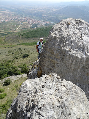
The ridge starts with easy I level climbs. // La arista comienza con pasos fáciles de I.


As we ascend, the ridge get sharper, more aerial and the difficulty turns to II, II+. We brought some friends and nuts with us, but we could finish the whole ridge using just some climbing slings and natural pro on the rocks. // Poco a poco la arista se va afilando, volviendose más aerea y aumentando la dificultad a II, II+. Llevamos friends y fisureros, pero realmente pudimos completarla con cintas rodeando rocas y algún puente de roca.


After a few climbs, we start an horizontal aerial section on the sharp ridge. // Después de algunas trepadas, hacemos una travesia horizontal por la arista afilada


After the horizontal section, the most diffcult III and III+ climbs. The limestone rock is rather decomposed, we have to watch out where we put our hands as sometimes the rock drop off the ridge. // Ahora vienen los pasos III+ y III, cada vez más aéreos. La roca está bastante descompuesta, hay que tener cuidado donde nos agarramos porque en ocasiones nos podemos quedar con la roca en la mano. Sin embargo, en general los agarres firmes son bastante buenos.


In the picture below we can appreciate the Juniper tree, which can be used as a reference. Right below the tree there is a piton or climbing spike which can be used to protect the climb to the Juniper. Once at the same level of the juniper tree, there is a small ledge to rest. The small tree can be used along with a sling  to protect our climbing partner. // Se aprecia la Sabina que habíamos indicado tomar como referencia al empezar la arista. Justo debajo de la Sabina se encuentra un viejo clavo para asegurar este tramo de subida. Una vez llegado al nivel de la Sabina, una pequeña repisa nos permite descansar. La Sabina tiene un tronco que parece bastante fuerte, y que hemos utilizado para asegurar al segundo en el paso más dificil.


After the ledge on the juniper tree, there is another III level climb, which will end in the holm oak tree, where the most difficult section of the ridge ends. // Después de la pequeña repisa en la Sabina, viene otra trepada de nivel III, hasta que llegamos a la encina que marca el final de la dificultad de la cresta.


Once we have reached the Holm oak tree, we have two options, we can wither descend using the parallel ridge we have at our left, or we can climb the wall on our right to arrive to the summit ridge of mount Laturce. // Una vez pasamos la Encina, tenemos dos opciones. O descendemos hacia un pequeño collado que nos lleva de bajada a la arista paralela más ancha, o ascendemos por nuestra derecha hacia la cima del Laturce tras una larga travesía por la Arista, ahora con nivel de dificultad mucho más bajo.

Views to Leza  canyon. // Vistas hacia el Cañón del Leza
In this area we have found some rocks detached from the wall. I have seen the pictures in one of the post I have used as reference for this activity and this detachement were not yet some years before. At the same time, in this area we have found many vultures. // En esta zona nos hemos encontrado varios desprendimientos. Curiosamente en las fotos de la entrada del blog http://angel-aparisi.blogspot.com.es/2011/11/arista-este-monte-laturce.html, estos desprendimientos no estaban todavía. Al mismo tiempo, nos hemos encontrado con bastantes buitres.

In the picture below we can appreciate the other easier ridge we can use to descend to the starting point. We climbed instead the wall on our right to ascend to the summit ridge. The climbs are easier now, but we keep advancing on simul climb with intermediate protections, since the terrain is slippery and a fall mortal. // En la foto de abajo se aprecia la arista paralela de menor dificultad que podemos usar para descender al lugar de partida. Nosotros nos encaramos en la pared para ascender a la arista cimera. Las trepadas son ahora más fáciles, pero aun así seguimos encordados en ensable con seguros intermedios, ya que el terreno es algo resbaladizo y la caida es mortal.

Once on the summit ridge, the terrain is easier, with I, II level climbs. We advance using simul climb, since there is another (the last) climb we have to overcome. // Una vez en la arista cimera, el terreno se hace más sencillo, con pasos de I, II. Aún así seguimos todo el rato en ensable usando rocas como seguros intermedios. También será necesaria en dos trepadas verticales que nos encontraremos más adelante.


El pueblo de Ribafrecha y el Valle del Leza
This is the last II climb we have to ascend before the summit ridge, I would recommend to protect this section with the rope since it is rather aerial to both sides. // Otra trepada de grado II que tenemos que afrontar en la arista dimera, y que conviene pasar asegurados.


Now, the ridge to the summit is much easier. // A partir de aquí recorremos la larga arista ya con escasa dificultad.


Once at Laturce summit (altarpiece, cross commemorating the battle of Clavijo), we will descend to the village using the normal path. We will pass by the hermitage of Saint James. // Una vez en la cima del Laturce (altar, cruz, en conmemoración a la batalla de Clavijo), descendemos por la senda marcada hasta la ermita de Santiago, donde cogeremos la pista asfaltada hasta el pueblo de Clavijo.


Before arriving to the village, there is a path which will lead us to the place where we parked the car in the morning. // Antes de llegar al pueblo, un camino correctamente señalizado marca la senda de bajada hasta el monasterio de San Prudencio, que nos llevará de vuelta a donde hemos dejado el coche.

Views of the ridge we have climbed. Only the first section has climbing difficulty, the reminder are I, II aerial sections which can be overcome with caution. // Arista completa que hemos recorrido. Sólo la primera parte tiene dificultad propia de escalada, el resto, una vez llegamos a la arista cimera, son pasos I, II, aéreos, pero que con cuidado se salvan perfectamente.


Cross in the summit of Mount Laturce // Cruz en la cima del Laturce

On our way back, the path goes through the monastery of San Prudencio, abandoned since 1800. The nature is taking over of the ruins, in spite of its gigantic dimensions. // En la bajada, el camino atraviesa el abandonado monasterio de San Prucenio, abandonado desde el 1800. La naturaleza poco a poco se va apoderando de él, a pesar de sus gigantescas dimensiones.


Restos de los arcos y puertas del monasterio. Los pisos más bajos parecen estar ya totalmente hundidos y enterrados en los escombros.


Perfil de la Cresta del Laturce desde su ladera sur, de vuelta al punto de partida
Summary / Resumen:

- Easy climbing on aerial ridges up to level III+, ideal to practice and settle knowledge of protected climbing. // Escalada fácil en arista aérea, hasta nivel III+, ideal para practicar y asentar conocimientos de asegurarmiento en escalada.

- The original idea of this activity was taken from these blogs. // La idea original fue gracias a los blogs de Chebaca y Angel Aparisi: http://tracksrioja.blogspot.com.es/2012/03/arista-e-de-monte-laturce-escalada.htmlhttp://angel-aparisi.blogspot.com.es/2011/11/arista-este-monte-laturce.html.

- The area is home to many colonies of vultures. It might be useful to check the nesting periods of these birds to avoid bothering them. At the same time, during some weekends the locals organize hunting, it might be useful to check before planning for the activity. // La zona es casa de muchas de las colonias de buitres que anidan por la zona, puede ser útil  informarse antes cual es el periodo de anidamiento de estas aves para intentar molestarles lo menos posible. Al mismo tiempo, hay fines de semana que se organizan cacerías por la zona, recomendable comprobar antes de planear la actividad.