sábado, 2 de enero de 2016

New Zealand - Fiorland - Key Summit

Track Description / Características de la Ruta:


Distance / Distancia: 4.14km 
Elevation Gain / Ascenso: 456m
Max / Min Altitude:  972m / 526m
Difficulty / Dificultad: Easy / Fácil
Alpine Grade: S.D. (Sin dificultad)
Activity: Hiking / Senderismo 
Recommended Cartography / Cartografía Recomendada: 


On our way to Fiorland, in the South Island, the road from Te-Anau to Milford is plenty of beautiful hikes which can be finished in just a few hours. Close to the parking place of Marian Lake, which we visited on the way to Milford, we find Key Summit, a modest mountain with beautiful views of the surrounding valleys and peaks of Fiorland. // De camino a Fiorland, en la Isla Sur, la carretera de Te-Anau a Milford está llena de recorridos maravillosos que pueden ser hechos en tan sólo unas horas. Cerca del parking de Marian Lake, que visitamos en nuestro viaje de ida a Milford, encontramos Key Summit, una modesta montaña con preciosas vistas de los valles y picos que le rodean.


By the road side, we find a big parking place with public toilets. The parking place is usually packed, since this is the starting/end point of the Routeburn track, one of the most famous multi-day treks in New Zealand. The track starts in Glenorchy, where we ascended Mount Alfred a few days before. From the parking place, we will follow for about 2.5km the Routeburn track. Then we will find a fork in the track. The path in our left is the Routeburn track, to ascend the Key Summit we will keep on our right. // A un lado de la carretera encontramos un gran parking con servicios públicos. El parking normalmente está muy frecuentado dado que es el inicio/fin del Routerburn track, uno de las actividades de senderismo de varios días más famosas de Nueva Zelanda. El track empieza en Glenorchy, donde ascendimos el Mount Alfred unos días atrás. Desde el parking, seguimos el camino  del Routeburn track unos 2.5km. Una vez llegados a la intersección, el camino de la izquierda es el del Routeburn track, nosotros nos quedamos en el de la derecha que asciende hacia el Key Summit.


As we ascend the slopes of Key Summit, the native forest disappears, and we get wonderful views of the valley where the road to Milford runs. // A medida que ascendemos las laderas de Key summit, el bosque nativo desaparece, y tenemos vistas maravillosas del valle por el que trascurre la carretera que lleva a Milford.


In front of us, we see the hanging glacier valley of Lake Marian, which we visited on the way to Milford the day before. // En frente de nosotros, el valle glaciar colgante donde se sitúa Lake Marian, que visitamos en nuestro camino de ida a Milford.


Summary / Resumen:
- Easy and short hiking activity with wonderful views on the surrounding area. Worth to visit on the one to or back from Milford sound. // Fácil y corta actividad con maravillosas vistas. Merece la pena visitarla a la ida o vuelta de Milford Sound.

viernes, 1 de enero de 2016

New Zealand - Okere Falls

Track Description / Características de la Ruta:

Distance / Distancia: 2.45 km 
Elevation Gain / Ascenso: 70m
Max / Min Altitude:  390m / 342m
Difficulty / Dificultad: Easy / Fácil
Alpine Grade: S.D. (Sin dificultad)
Activity: Hiking / Senderismo 
Recommended Cartography / Cartografía Recomendada: 


In the Bay of Plenty, close to Lake Rotorua, we find Okere Falls. On the Kaituna river, on its way to Pacific Ocean, one of the drains of the lake has formed a nice spot for extreme rafting and kayaking. For those who do not practice any of these sports, there are a conditioned path going along the river to enjoy the beauty of the place. If you are interested in whitewater rafting on the area, visit the DOC website for Okere Falls in order to look for commercial operators. // En la Bay of Plenty, cerca del Lago Rotorua, encontramos las cascadas de Okere. En el río Kaituna, en su camino hacia el océano Pacífico, este sumidero natural del lago ha formado un entorno maravilloso para el kajaking y el rafting. Para aquellos que no practican estos deportes, existe también un camino acondicionado a lo largo de la primera parte del río que nos permite descubrir la belleza del lugar. Si estás interesado en actividades de rafting en la zona, visita la web del DOC para las Okere Falls con el fin de buscar operadores comerciales que trabajan en la zona.


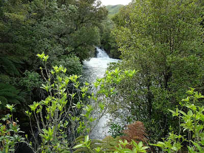
The path along the river is well marked, and we can get nice views from the small waterfalls. // El camino a lo largo del río está bien marcado, y tenemos buenas vistas de las diferentes cascadas.


Along the path we spotted several entry/exit points for kajaking and rafting. // A lo largo del camino vemos varios puntos de entrada y salida para kajaking y rafting.


At the end of the path, close to the second parking place, there are a nice look-out with a bridge crossing the river. Be careful if you go down to the river level, the rock is very slippery and the water stream very strong. // Al final del camino, cerca al segundo parking, existe un mirador y un puente que cruza el río. Tened cuidado si bajáis al nivel del río, ya que la roca es bastante resbaladiza y la corriente de agua muy fuerte.


On the way back, we visited the ruins of an old water power station, as well as the cove in the main waterfall. This place was used by native population as a shelter in time of wars. // En el camino de vuelta, visitamos las ruinas de una antigua estación hidroeléctrica y una cueva que existe en la cascada. Al parecer, este lugar fue usada por la población nativa como un refugio en tiempos de guerra, dada su inaccesibilidad.


Summary / Resúmen:
- Easy 1 hour hike to visit the first section of the Kaituna river. Walking along a conditioned path, you are not expected to leave the path, falling down to the river might have undesired consequences. // Ruta fácil de 1 hora que nos permite conocer la primera parte del río Kaituna. Caminad siempre a lo largo del sendero acondicionado, con la fuerte corriente de agua, caer en el río puede tener consecuencias no deseadas.

New Zealand - Lake Okataina


Track Description / Características de la Ruta:

Distance / Distancia: 12.60 km 
Elevation Gain / Ascenso: 363m
Max / Min Altitude:  509m / 395m
Difficulty / Dificultad: Easy / Fácil
Alpine Grade: S.D. (Sin dificultad)
Activity: Hiking / Senderismo 
Recommended Cartography / Cartografía Recomendada: 


Starting our New Zealand adventure on the North Island, one of the mandatory stops is the area of Bay of Plenty and Rotorua. The Okataina Lake has a lot of possibilities, from tramping and one-day hiking to mountain biking, kajaking and fishing. // Comenzando nuestra aventura Neo Zelandesa en la isla Norte, una de las paradas obligatorias es la Bahía de Plenty y la zona de Rotorua. El Lago Okataina tiene muchas posibilidades, desde senderismo de varios días y excursiones de unas horas, hasta bici de montaña, canoa y pesca.


By the parking place, we have a hotel, a bar/restaurant as well as public toilets. I do not remember if free camping was allowed at this place, but with no doubt, staying overnight on the lake's shore must be a nice experience. By the public toilets, we see a map with the hiking/tramping activities we can do on the area. // Junto al parking tenemos un hotel, bar/restaurante así como baños públicos. No recuerdo si la acampada libre está permitida en este lugar, pero sin duda, pasar una noche a orillas del lago debe ser una experiencia maravillosa.


We hiked the path going along the shore of the lake. The walk go till the Lake Tarawera camping area, but we shortened the activity to a 4 hours return hike. Enough to catch the beauty of the area. // Caminamos por el sendero que discurre por la orilla del Lago. El sendero va hasta la zona de camping del Lago Tarawera, pero acortamos la actividad a una caminata de 4 horas ida y vuelta. Lo suficiente para captar la belleza del lugar.


The forest, as many others areas in New Zealand, is full of possum traps, in order to combat this invasive specie which is killing the local birds such as Kiwis and Keas. // El bosque, como muchas otras areas de Nueva Zelanda, está llena de trampas para possum, con el fin de combatir la especie invasora que está matando a mucha fauna local, especialmente Kiwis y Keas.


On the way back to the parking, with the sunlight of the noon, the lake water reminds me to exotics Caribbean beaches. // De vuelta al parking, con la luz del mediodía, las aguas del lago me recuerdan a exóticas playas del Caribe.


Remarks:
- Easy activity, well marked path, we can find a couple of beaches in the track in case we want to refresh our bodies. // Actividad facil, camino bien marcado, podemos encontrar un par de playas en el camino en el caso que nos queramos refrescar.
- There is no water sources on the whole path, so, bring water with you. // No hay agua durante todo el recorrido, así que es importante llevarsela.
- Visit the DOC website for more information on other activities and commercial operators. // Recomiendo visitar la página web del DOC para tener más información sobre la cantidad de actividades y operadores comerciales de la zona.