
Track Description / Características de la Ruta:
Distance / Distancia: 8.42 km
Elevation Gain / Ascenso: 816 m
Max / Min Altitude: 1417m / 718m
Difficulty / Dificultad: Moderate / Moderado
Activity: Advanced Trekking / Senderismo Avanzado

Ioar is the highest point in Codés Mountain Range, a range between the province of Álava and Navarre close to the Ebro Valley. The track starts at Santuario de Codés, on the foothill of the mountain range, a Monastery close to Torralba del Río, in Navarre province. A limestone massif, as most of the mountain ranges in this region, the southern and northerern slopes show big differences in terms of vegetation and climatology. The shouthern side, with a drier climatology, has a mediterranean forest, with mainly holm-oak, while the northern side, with a wetter climatology from the rains coming from the Biscay Bay, is populated with oak and beech tree forests. // Ioar is la cima más elevada en la Sierra de Codés, en la linde entre Álava y Navarra cercana al valle del Ebro. El track comienza en el Santuario de Codés, en las faldas de la Sierra, cercano a la localidad navarra de Torralba del Río. Situado en un macizo de piedra caliza, como la mayoría de los macizos de esta region, las caras norte y sur muestran una gran diferencia en términos de vegetación y clima. La cara sur, con un clima más seco, está poblada por bosque mediterráneo, principalmente pequeñas carrascas, mientras que la cara norte, con un clima más atlántico debido a las lluvias que vienen del Golfo de Vizcaya, está poblada por robles y hayas.

Being one of the most representative mountains in the area, there are many different paths leading to the summit. This track describes the ascent through the Valle de los Penitentes, using a narrow path on the base of the limestone towers of Dos Hermanas and Peña Blanca. Observe that the ascent by this path is the most difficult part of the trek. As usual, I prefer doing the most difficult terrain on the way up, and then climb down the mountain using the easier way (so, avoid doing the track the other way around). Furthermore, I would advise against using this way up after rainy days when the terrain is wet. The path is steep, the rock can be slippery and the terrain muddy. // Siendo una de las montañas más representativas de la zona, existen muchos itinerarios de ascensión. Este track describe la ascensión por el Valle de Los Penitentes (en referencia a los gigantes de roca caliza), a través de un estrecho camino en la base de las torres calcáreas de Dos Hermanas y Peña Blanca. Observad que el camino usado para la ascensión es la parte más dura de la actividad. Como siempre, yo personalmente prefiero hacer el terreno más dificil a la subida, dejando la parte fácil para la bajada. Adicionalmente, desaconsejaría ir por el camino del Valle de Los Penitentes después de días lluviosos, ya que la senda es estrecha, empinada, la roca puede estar resbaladiza y el terreno embarrado.

Once we are at the monastery, we follow the road on our left, finding after a few meters a small parking place. The path quickly enters the holm-oak forest traversing the south slope of the range, driving us to the other side of the limestone wall. // Una vez hemos aparcado en el monasterio, seguimos la carretera a nuestra izquierda, encontrándonos a unos pocos metros un pequeño parking. El camino rápidamente entra en el carrascal, rodeando la cara sur de la sierra, y conduciendonos al otro lado del muro de caliza de Dos Hermanas.


After 2km, once we are at the other side of the limestone wall of Dos Hermanas and Peña Roya, we start at the base of the valley we have to climb up. The path, running on the base of this limestone giants, quickly becomes steep, messy and difficult to follow. There are rock piles signaling the way, but it can be easy to miss one of them, ending up in the middle of the holm-oak forest. In this case, step back and try to find again the rock piles instead of finding your own way up. From this point, the track is a continuous ascent of 700m altitude gain, but the views are worth it. // Después de unos 2km, una vez estamos en la cara oeste de la pared de caliza de Dos Hermanas y Peña Blanca, estamos en la base del Valle de Los Penitentes que tenemos que ascender. El camino, que asciende por la base de la pared de caliza, rápidamente se empina, siendo un poco lioso y dificil de seguir. Hay hitos de rocas señalando el camino, pero puede ser fácil saltarse uno de ellos y acabar en el medio del carrascal. En este caso, mejor volver atrás hasta encontrar el último hito visto en lugar de abrirnos nuestro propio camino por el bosque. A partir de este punto, el camino es un ascenso continuo de 700m de desnivel, pero las vistas merecen la pena.


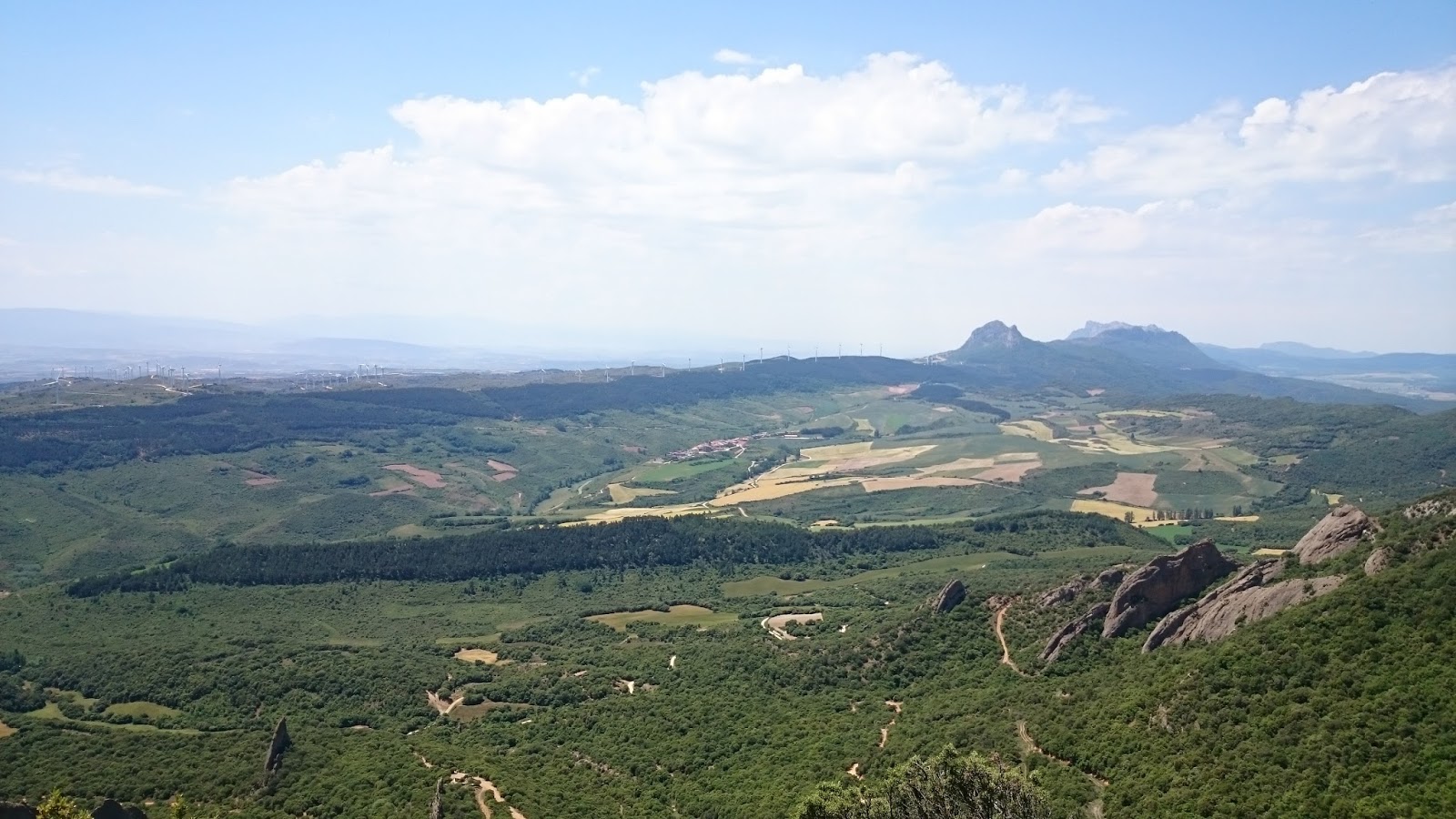
As we gain altitude, at around 1050m level, the forest opens, and we have better views of the valley we are ascending. We can spot the Ioar peak (the one with big red and white aerials), the limestone giants (The Penitents), and the southern mountain ranges of Basque Country as well as the 2000m mountains of La Rioja. A medida que ganamos altura, sobre los 1050m el bosque se abre, y tenemos mejores vistas del valle que acabamos de ascender. Ya podemos ver la cumbre del Ioar, con su antena blanca y roja, los gigantes de caliza (Los Penitentes), las Sierras del Sur de Euskadi así como las cadenas de 2000m de La Rioja.


After the 1050m level, the forest dissapears, and the way up is obvious. We will walk right on the ridge of Peña Roya, to have views of both sides of the valley. On our left, the Peninten Valley we just climbed up, on our right, the valley where the Codés Monastery is, the starting point of the track. // A partir de los 1050m, el bosque desaparece, y el camino de subida es obvio. Ascenderemos un poco hacia la cresta de Peña Roya para poder disfrutar de las vistas a ambos lados del valle. A nuestra izquierda el Valle de Los Penitentes por el que hemos subido, a nuestra derecha el Monasterio de Codés, desde donde comenzamos la ruta.


Ioar summit is closer and closer... // La cima del Ioar cada vez está más cerca...


Once at the summit of Ioar, amazing views of the Southern region of Basque Country and Navarre. On the picture below, Cresta de La Costalera, an easy climbing on a narrow and impressive mountain ridge (III+ level, aerial pass and 12m rappel). To be done soon... // Una vez en la cima del Ioar, impresionantes vistas del Sur de Euskadi y Navarra. En la foto de abajo, la Cresta de La Costalera, una actividad de aristas fácil (nivel III+, paso aereo y rappel de 12m)... Espero hacerla pronto.

Views of the Penitent Valley we climbed up, from the summit of Ioar. // Vistas del Valle de Los Penitentes por el que hemos ascendido, desde la cima del Ioar.

Views of Cantabria Mountain Range, which separates Alava and La Rioja provinces. // Vistas de la Sierra de Cantabria, que separa las provincias de Álava y La Rioja.

Views towards north, Alava and most of the Basque Country can be seen from here. We can easily recognize the main mountain massifs (Gorbea, Anboto, Aizkorri, Aralar, Urbasa, Beriain) on a clear day. // Vistas hacia el Norte, Álava y el resto de Euskadi pueden verse desde aquí, pudiendo reconocer los macizos principales (Gorbeia, Anboto, Aizkorri, Aralar, Urbasa, Beriain) en los días claros.


On our way back, we descent using the northern side, through a beech tree forest. // En el camino de bajada, descendemos por la cara norte del Ioar atravesando un hayedo.


The forest opens discovering green meadows. // El Hayedo se abre y una bonita campa verde (La Llana) aparece.


Then we have to turn right (south) towards the mountain pass. // Una vez en La Llana, giramos a la derecha, dirección sur, hacia el Collado.

Once at the mountain pass, the way down is obvious, following the GR marks (red and white) which will lead us back to the Monastery. // Una vez en el Collado, el camino de bajada al monasterio es evidente, siguiendo las marcas del GR (rojas y blancas) y los hitos de piedra.

Again, we share the way down with these amazing limestone giants // De nuevo, compartimos la primera parte de la bajada con estos gigantes de caliza.


Summary / Resumen :
- Moderate activity for the ascent to Ioar, a representative mountain on southern Basque Country and Navarre region. The way up is demanding physically, and can be a little technical in some points. Avoid this track after rainy days when the terrain is wet. The way down, although it can be demaing, is safer. Also, I would discourage from following the track the other way around.// Actividad moderada para ascender al Ioar, una montaña representativa del Sur de Euskadi y la Rivera Navarra. El camino de subida es exigente físicamente, y puede ser un poco técnico en algunos tramos. Evitar este camino en los días después de lluvias, cuando el terreno está mojado. El camino de bajada, aunque empinado, es más seguro. Aconsejo realizar el track en el sentido realizado y no a la inversa.
- Although most of the track is done within an holm-oak forest, in summer time the weather close to the Ebro valley can be hot, so, best season for this trek is probably from Fall to Spring. // Aunque la mayoría del itinerario discurre por un bosque de carrasca, en verano el tiempo puede ser bastante caluroso, creo que la mejor época para realizar la actividad es de Otoño a Primavera.


